Permit holders must immediately suspend previously approved water withdrawals from Nicola Lake issued under Section 10 of the Water Sustainability Act, due to record low lake levels.
DATE ISSUED: Dec. 8, 2025
EFFECTIVE DATE: Immediately
The following table provides a summary of the current suspensions in the province.
Legend:
- “Open” = water diversion/use allowed, as permitted
- “Closed” = water diversion/use suspension in effect
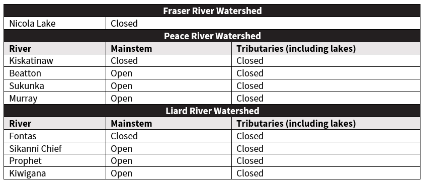
No additional BCER-issued water diversion/use suspensions are currently in place beyond those listed in the above table.
Diversion and use of water stored in dugouts or dams is not suspended. Basins across B.C. are being monitored and further suspensions of water diversion or use are possible depending on conditions.
Given local variability, it is possible some streams in the areas under suspension will have recovered sufficiently to allow some water withdrawal. The BCER will review new applications for diversion or use, or requests to use existing approvals, on a site-specific basis.
Permit holders can discuss suspensions with the BCER and submit requests for continued water diversion or use under existing Section 10 approvals by providing location-specific data and subject matter expert opinion relevant to local streamflow conditions.
Operators are requested to do the following to support their applications or requests to use existing Section 10 approvals:
- Limit the applications to water volumes and points of diversion that are realistic to the specific operational needs for the upcoming months.
- For new applications for diversion or use of water from rivers and streams, or to request use of existing approvals, include discharge measurements at the points of diversion or use to provide information on current flow conditions in relation to the volumes of water requested. The discharge measurements should be collected to an acceptable hydrometric standard by a qualified individual.
- For new applications for diversion or use from lakes, or reactivation of existing approvals, provide information on lake bathymetry:
- Surface area (hectares).
- Depth (metres). If lake depth information is not already available from provincial databases or previous surveys, obtain depth measurements at points along two transects representing the long and short lake axes, to determine maximum lake depth.
- Volume.
BCER’s Water Management Program
The BCER actively manages energy resource sector water use in British Columbia, prioritizing environmental protection and community needs.
The BCER’s hydrology specialists participate in the Provincial Technical Drought Working Group and use tools such as the Northeast Water Tool and real-time Water Survey of Canada data to determine when and where suspensions are required. The BCER also collaborates with Indigenous Nations, the Ministry of Water, Land and Resource Stewardship, and other partners to monitor local conditions and respond quickly to changes. Each year, the amount of water withdrawn by industry in northeast B.C. is a fraction of a per cent of the region’s mean annual runoff.
The BCER publishes quarterly water use summary statistics, which are available on the Reports page. For more information about our water management program, visit our Water Management page or view the Water Use in Oil & Gas Activities video.
See also the B.C. Government’s Drought Information page and Drought Information portal
If you have any questions regarding this Directive, please contact:
Ryan Rolick, M.Sc., P.Geo.
Hydrologist
BC Energy Regulator
Ryan.Rolick@bc-er.ca
250-794-5213
Nicole Curnow
Executive Director, Responsible Stewardship
BC Energy Regulator
Nicole.Curnow@bc-er.ca
250-419-4343
For media inquiries, please contact:
communications@bc-er.ca