The Northeast District Cumulative Impacts (Treaty 8) Order (OIC 255/2024) (the CI Order) applies to 12 natural resource sector statutes in the northeast of British Columbia (B.C.). The Ministry of Water, Land and Resource Stewardship (WLRS) is coordinating the CI Order’s implementation across natural resource sector agencies in northeast B.C. Effective September 2024, publicly available cumulative effects current condition values/data are being employed to support the consideration of cumulative effects by decision-makers. These include:
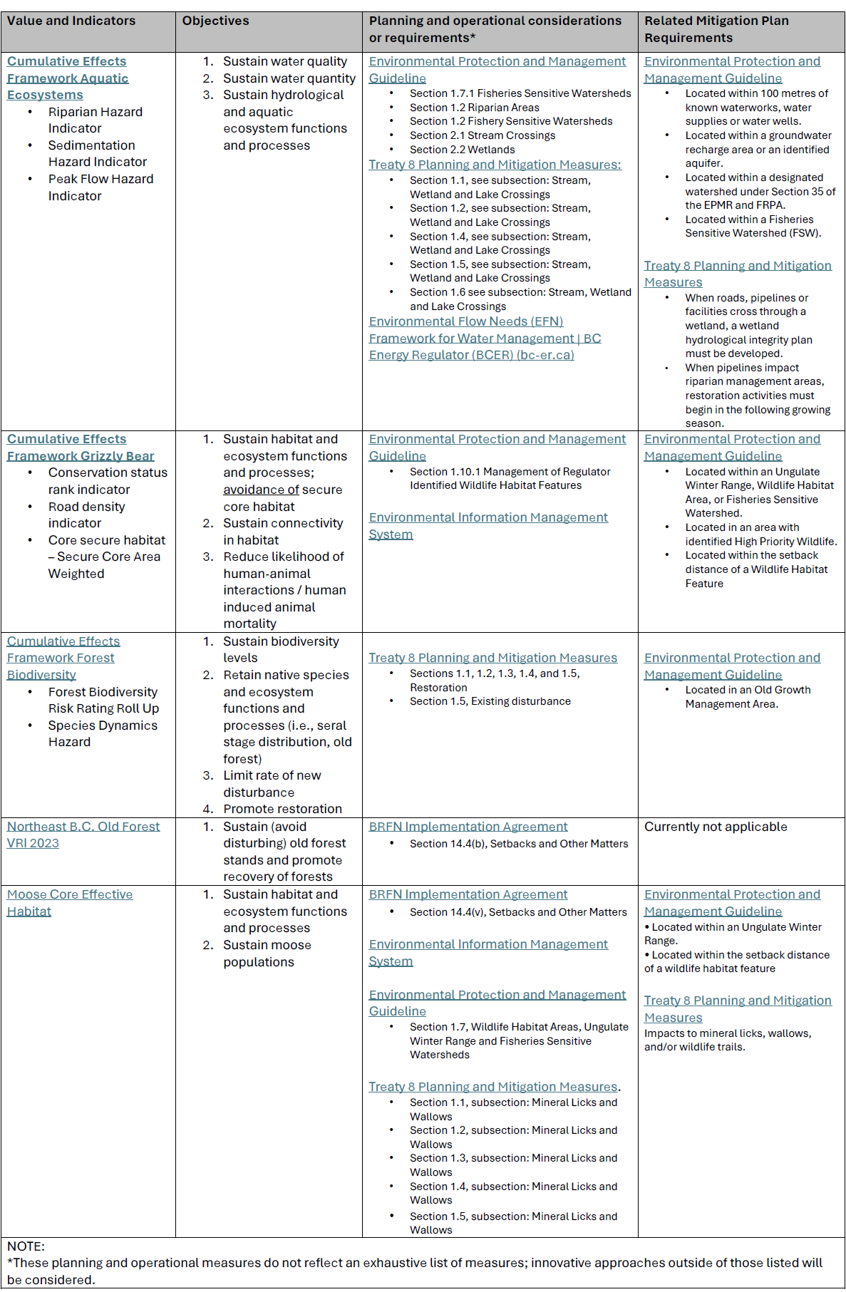
- Cumulative Effects Framework Aquatic Ecosystems
- Cumulative Effects Framework Grizzly Bear
- Cumulative Effects Framework Forest Biodiversity
- Northeast B.C. Old Forest VRI 2023*
- Moose Core Effective Habitat*
* These values are linked to commitments set out in the BRFN Implementation Agreement. Currently, conversations with other Treaty 8 First Nations regarding the use of these two datasets is ongoing.
This initial selection of publicly available information is a starting place for the consideration of cumulative effects. This information does not preclude the integration of other important sources of information in decision-making that may become available through consultation, shared decision-making, project planning and other mechanisms. New data and information from Treaty 8 First Nations will inform decisions that may impact Treaty 8 First Nations’ way of life.
Table 1, below provides more information about each of the current condition values/data sets listed above, including: the purpose, planning considerations and effects that will require a development of a mitigation plan. Applications made to the BCER must consider this information in the planning and preparation of submissions in the northeast of B.C.
Table 1. Cumulative effects current condition values/data with example best management practices
Rationale for the selection of grizzly bear
Grizzly bears are wide-ranging, opportunistic omnivores and have low reproductive and dispersal rates. Grizzly bears are an excellent indicator species for cumulative effects, due to their dependence on well-connected habitats and properly functioning ecosystem processes. Consideration of CEF Grizzly Bear data in planning promotes conservation of habitat connectivity and variety which benefits many other species, including furbearers and ungulates.
Other industrial and commercial activities
The CI Order requires decision-makers to consider a proposed activity’s duration, geographic extent and the cumulative impacts of the activity in the context of the impacts of other industrial and commercial activities on the treaty rights. Applications made to the BCER must describe and demonstrate the coordination of other proposed activities with other companies and sectors, to reduce and consolidate the industrial footprint and reduce cumulative effects. Key sources of data representing other industrial and commercial activities can be accessed via the provincial data catalogue. The BCER recognizes other sources of information exists and must also be utilized, where appropriate.